
NBC10 First Alert Weather meteorologist James Gregorio says that the Philadelphia region should expect some rain on Sunday, but the worst of it should move south of the city.
What to Know
- Thunderstorms had threatened to bring damaging wind and flooding downpours to the Philadelphia region on Sunday, March 16, 2025.
- Sunday's severe storm threat has diminished overnight after light showers and sprinkles on Saturday.
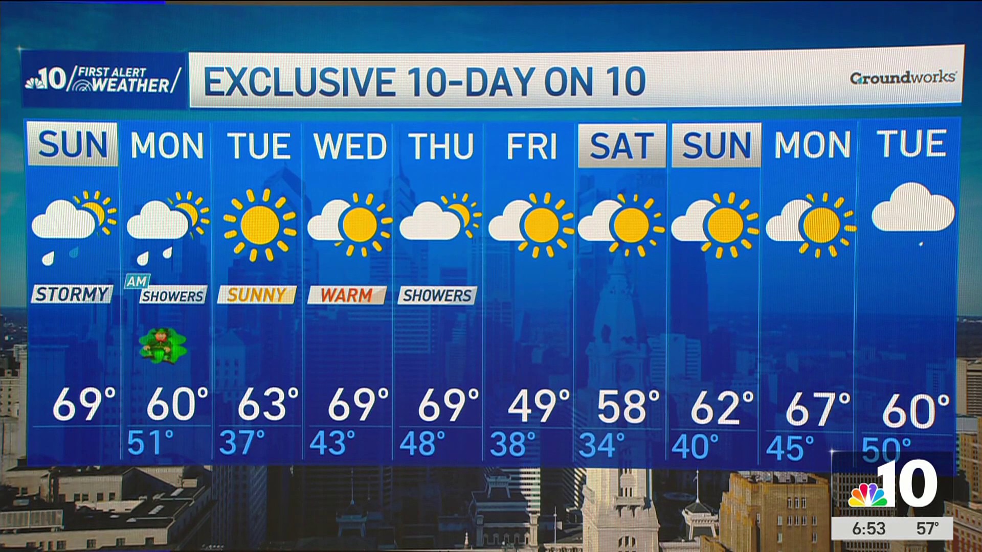
- Temperatures should remain warmer than normal throughout the weekend, but winds on Sunday will have it feeling cooler.
- Be sure to have the latest version of the NBC10 app downloaded to your device to ensure you can get weather alerts and the latest forecast, even if you lose power.
Celebrating St. Patrick's Day a little early this weekend? You might want to keep a green poncho handy as there are a couple chances for rain and the possibility of severe storms before the end of Sunday.
The NBC10 First Alert Weather Team saw a storm that could have brought damaging wind, flooding downpours and severe thunderstorms for the entire Philadelphia region for 3 p.m. on Sunday, March 16, 2025, through midnight has moved south.
Get top local stories in Philly delivered to you every morning. Sign up for NBC Philadelphia's News Headlines newsletter.
Storms are still expected to move through the Philadelphia area Sunday night with heavy rains and gusty winds, but the conditions will not be as severe as previously thought.
Here's what you need to know:
Rain expected to hit after the St. Patrick's Day Parade on Sunday ⛈️
Weather Stories
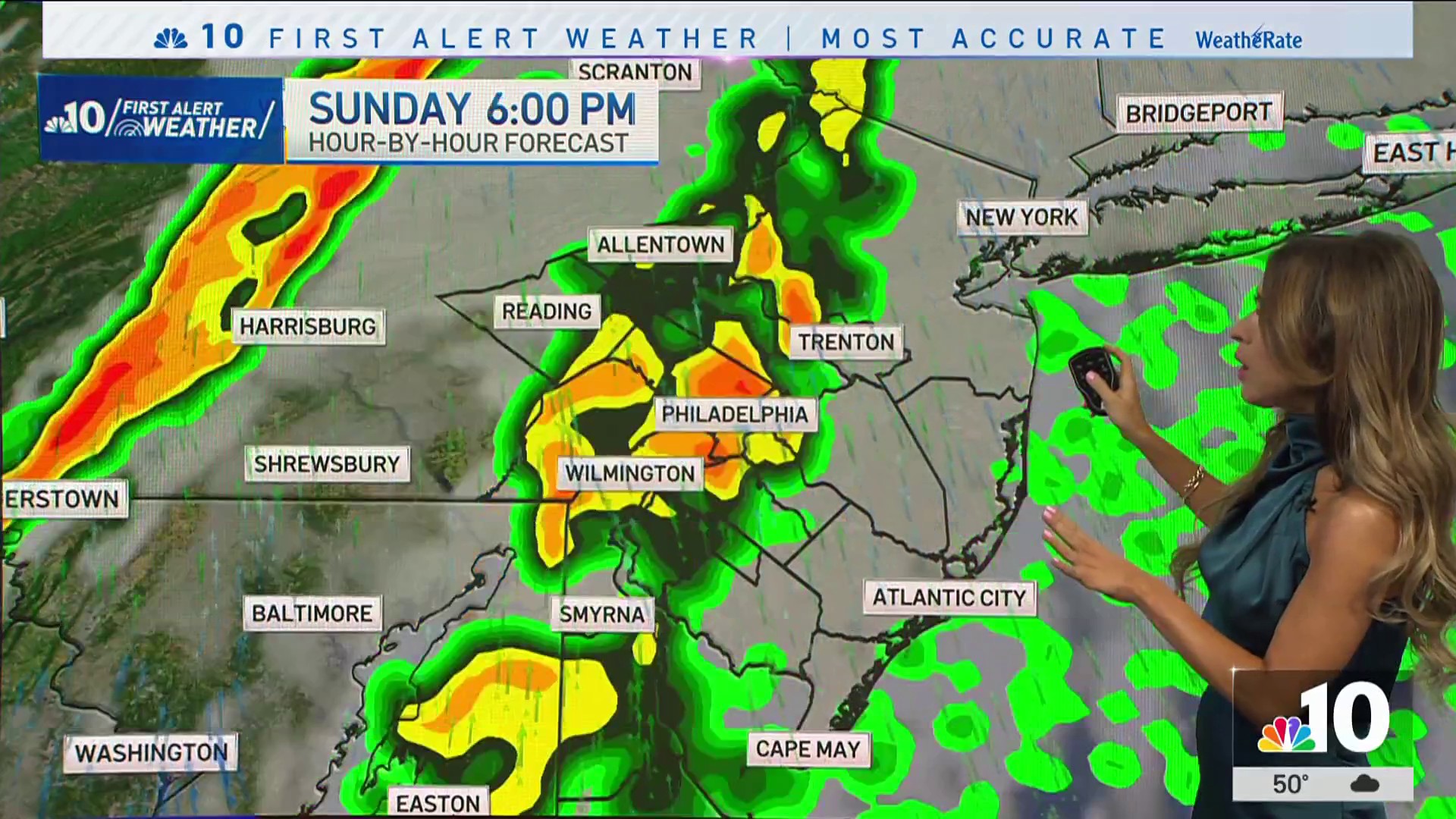
Sunday was expected to be the main event, with gusty winds ahead of a powerful cold front.
Scattered showers are still expected Sunday night, but strong winds and severe rains are expected to move south past the area.
Those who attended the Philadelphia St. Patrick’s Day Parade on Sunday (here's your guide to the action), saw cloudy, windy and mild conditions, with scattered light showers, but the parade wrapped up before the worst of the storm moved in.

Heavier rain is expected to hit the Philadelphia region late Sunday night.
By Monday morning, any lingering showers will clear out, leading to a nice St. Patrick’s Day (March 17) with sunshine and cooler, but comfortable conditions.
Airport delays, power outages due to the stormfront
The Philadelphia International Airport has had a few delays and cancelations ahead of Sunday's expected storm.
A ground delay was in effect at the airport from 5 p.m. ET until 7:59 p.m. ET. Departures to the airport were delayed on average of 42 minutes due to the wind.
As of about 9:30 p.m., there were 322 total flight delays and seven cancellations at the airport.
Power outage numbers were relatively low throughout the region as of 10:30 p.m. on Sunday.
PECO has reported 453 outages:
- Bucks County: 87
- Chester County: 132
- Delaware County: 135
- Montgomery County: Fewer than 5
- Philadelphia: 85
- York County: 9
For a map of outages in PECO's service area, click here.
First Energy has reported about 221 power outages as of about 10:30 p.m. on Sunday:
- Berks County: 121
- York County: 94
For a map of outages throughout First Energy's service area, click here.
PSEG is reporting about 514 power outages as of Sunday night, mostly in Burlington County:
- Burlington County: 459
- Mercer County: 42
For more details or a list of outages in PSEG's service area, click here.
Atlantic City Electric is reporting 733 power outages throughout its service area on Sunday.
- Atlantic County: 133
- Camden County: 573
- Cape May County: 16
- Gloucester County: 11
A full list of closures and Atlantic City Electric's service map is available here.
And, Delmarva Power is reporting about 82 power outages as of about 10:30 p.m. on Sunday, all in New Castle County.
For a full service map and outages for Delmarva Power, click here.
Sign up for our Breaking newsletter to get the most urgent news stories in your inbox.