
NBC10's First Alert Weather team issued a First Alert for Sunday as storms -- and severe weather -- moved through the region during the afternoon.
Damaging winds, flooding and power outages were seen in some parts of the region like the Lehigh Valey and Bala Cynwyd.
Storms leading into Sunday
The weekend kicked off with cloudy skies and warmer temperatures before severe thunderstorms passed through on Saturday night.
Get Philly local news, weather forecasts, sports and entertainment stories to your inbox. Sign up for NBC Philadelphia newsletters.
The National Weather Service issued a severe thunderstorm watch for our region that was expected to be in effect until 11 p.m. Saturday night but canceled it just before 10 p.m.
This round of severe weather will push to Philadelphia after midnight and into Sunday morning.

The system weakened as it made its way down into southern New Jersey and northern Delaware.
Weather Stories

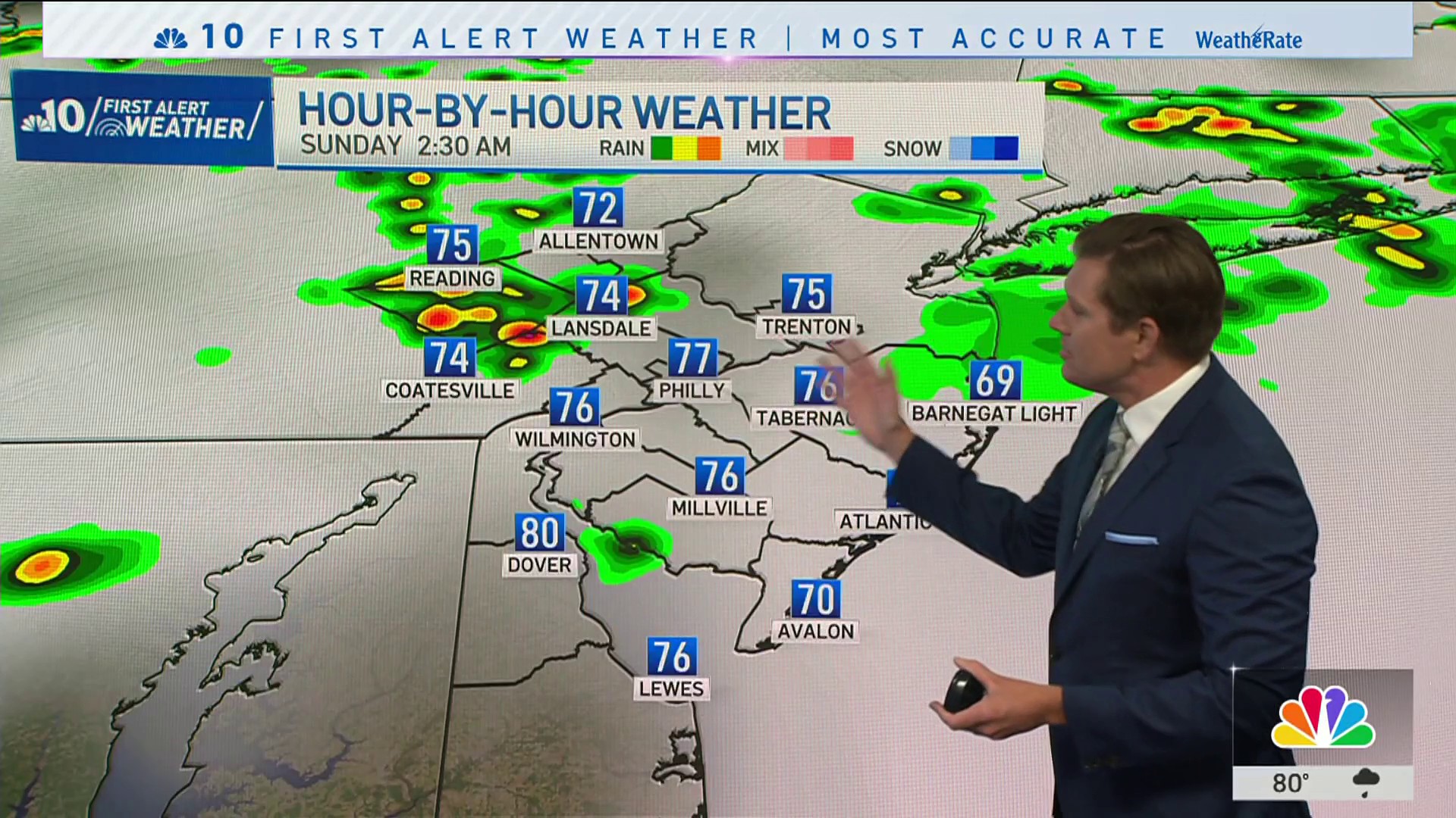
Of greater concern for our entire area are the storms that are forecasted to arrive Sunday later in the afternoon and evening.
Severe weather Sunday
Sunday will start mostly cloudy but quickly become sunny. This will charge up the atmosphere for severe weather later in the day.
As of about 11:45 a.m., the NBC10 First Alert Weather team issued a severe thunderstorm watch, as well.

NBC10's First Alert Weather team is expecting the storms to roll into Philadelphia at about 4 p.m.
A silver lining in this forecast is the persistent cloud cover over the region. With clouds hanging tough, temperatures have been held down today, and energy in the atmosphere has been reduced.
Because of this, South Jersey, and Northern Delaware could escape the worst of the severe weather as it presents now.
Storms are expected to spread from the northwest to the southeast.
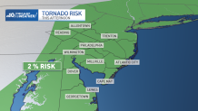
Strong damaging winds, hail, heavy rain and an isolated tornado remain in the forecast.
Highs today in the middle and upper 80’s with intense humidity.
Higher temperatures on Sunday will easily reach mid-90s with feels like temperatures reaching over 100 in some neighborhoods.
Storms are expected to begin first across the Lehigh Valley after 2 p.m. before they shift down to Philadelphia and the surrounding suburbs between 4 and 6 p.m.
Eventually, the storms will work down to the Jersey Shore and Delaware beaches after 8 p.m.

The biggest concern for these storms on Sunday is that they have a high potential of causing wind damage.
This system has the highest likelihood of producing a tornado that we've seen so far this season.
A 1-2% tornado risk remains, but with clouds in place.
Be weather aware
Be sure to keep watching NBC10 News and have the most updated version of the NBC10 app downloaded to your device to get the latest weather forecasts and conditions in real-time.
Should you be in the path of a tornado warning, seek shelter immediately in a basement of interior room with no windows until the threat passes.
People should make sure to weigh down outdoor furniture and trashcans. You should also be prepared for possible power outages.
Sign up for our Breaking newsletter to get the most urgent news stories in your inbox.
