What to Know
- Standing water still remains in some spots 24 hours after Tropical Storm Isaias passed through the region
- Cleanup efforts are underway and utility services are working to restore power. Some hard-hit spots, particularly Long Beach Island, may be without power for days.
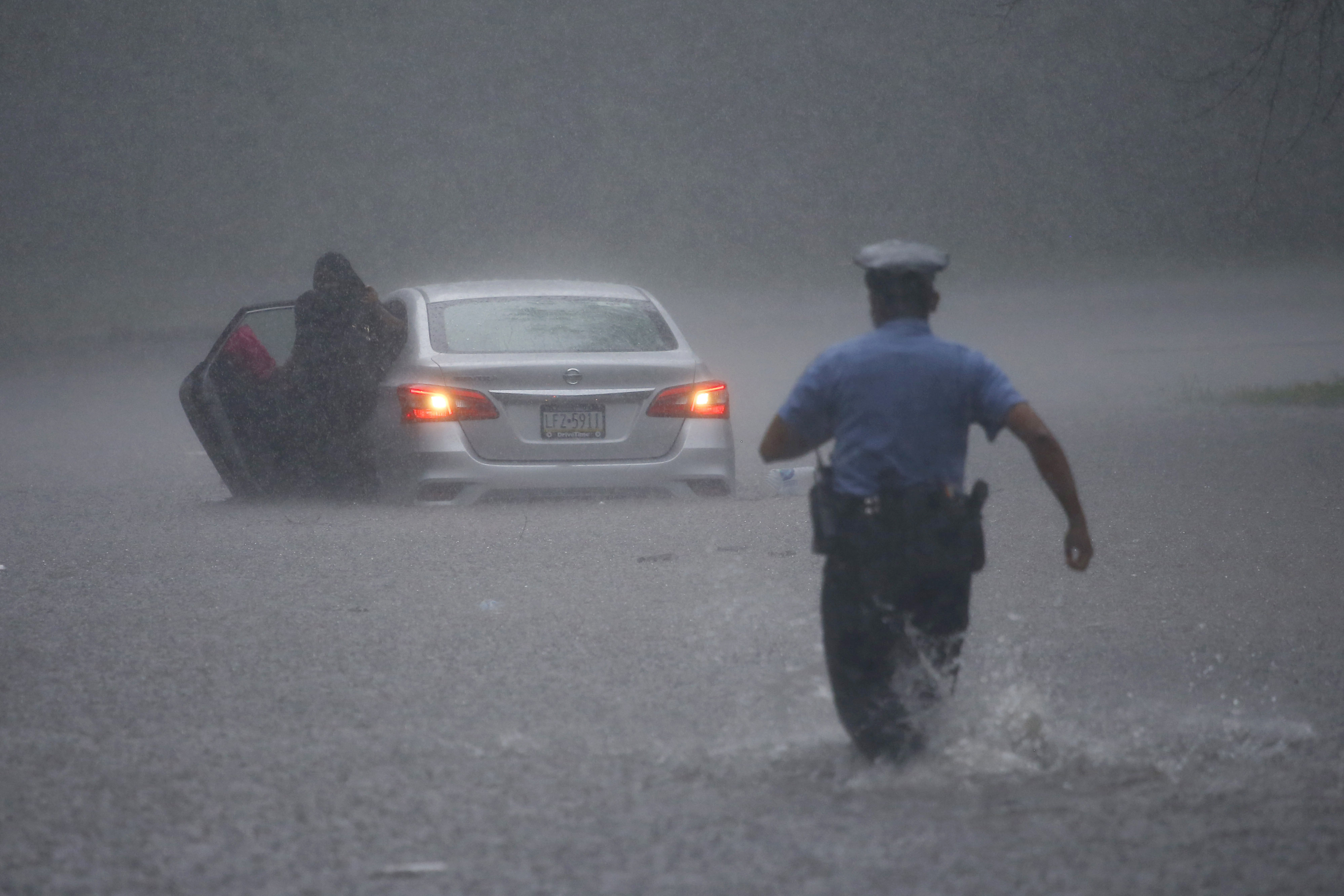
- About 200 people were rescued from flooded areas in Philly, mostly in Eastwick and Manayunk along the Schuylkill.
Overnight flooding from Tropical Storm Isaias has led to water still lingering in some spots of our region, particularly along the Schuylkill River.
Since Isaias hit in Philly Tuesday, at least 200 people needed rescue, Fire Commissioner (and Emergency Management director) Adam Thiel said at a news conference Wednesday. Most of those people were in Eastwick or Manayunk.
The city is still documenting flood damage and working with PEMA, FEMA and the city Commerce department to possibly get relief dollars to people whose properties were damaged. The city has to meet a certain threshold of damage to qualify for that aid, Thiel said.
A common refrain among residents he visited around the city Wednesday: "It’s flooded here before, we’re used to this, but this was bigger than we’re used to."
"This was more than nuisance flooding," Thiel added. "The folks in Eastwick, they’re pulling stuff out of their homes, there are cars that are being opened up. Manayunk, we had cars floating, we had significant damage to buildings."
Of the financial impact, "I would estimate that easily it runs into the millions of dollars," Thiel said, noting that not all damage in less-impacted neighborhoods had been accounted for.
"This is on top of COVID and all the other things that folks are dealing with around the city," Thiel said.
About 160 Philadelphians who suffered flood damage are expected to stay in hotel rooms provided by the Red Cross.
The flood level of the Schuylkill at Philadelphia reached around 13.3 feet in Philadelphia, above its flood stage of 11 feet.
Thiel said Tuesday that city rescue workers evacuated more people from Isaias than they did during Superstorm Sandy.
At daybreak Wednesday after cresting overnight. Water remained, however, along parts of Main Street in Manayunk.
A flood warning along the river remains in place until 4 p.m. as water levels remained high.
Flooding on the Schuylkill late Tuesday night likely led to a barge striking the pillars of the Vine Street Expressway Bridge. I-676 was closed in both directions between I-76 and Broad Street and remained closed Wednesday morning. SEPTA services were impacted, leading to Regional Rail cancellations and detours between 30th Street and Suburban Station. But services returned to their previous schedules by 3 p.m. Wednesday.
Tugboats will come out and fetch the barge Thursday, the Army Corps of Engineers said at the news conference with Thiel.
In Southwest Philly, 200 homes were affected by floodwaters from the Darby Creek.
Meanwhile, the flood level of the Schuylkill River at Norristown was expected to reach 20.5 feet, well above the major flood level, around 2 a.m. Wednesday. Water started to recede Wednesday morning.
During the day, flood level records were already set for Perkiomen Creek at Graterford, Pennsylvania, with 19.4 feet, the highest level since 1935 and in Little Lehigh Creek near Allentown, Pennsylvania, with 12.69 feet. Flood levels in both creeks should come down overnight.
Delaware Route 1 southbound near Odessa was closed as the storm caused multiple tractor-trailers to tip over. The Kelly Drive in Philadelphia was eventually closed due to flooding.
People had to be evacuated from homes along the Darby Creek, Cobbs Creek was swollen to its banks, and flooding occurred along the Schuylkill in Reading. Overflow from the Christina River in Delaware also caused major flooding.
In Upper Saucon Townsip, a 44-year-old woman died after her vehicle was swept away by floodwaters.
In Upper Darby, viewer-submitted video showed three people trying to escape a Chinese restaurant that appeared to be filling up with water. The intersection around Marshall and Hampden roads was so flooded that a bystander had to swim to get across the street. He helped the people inside break a window to get out of the restaurant safely.
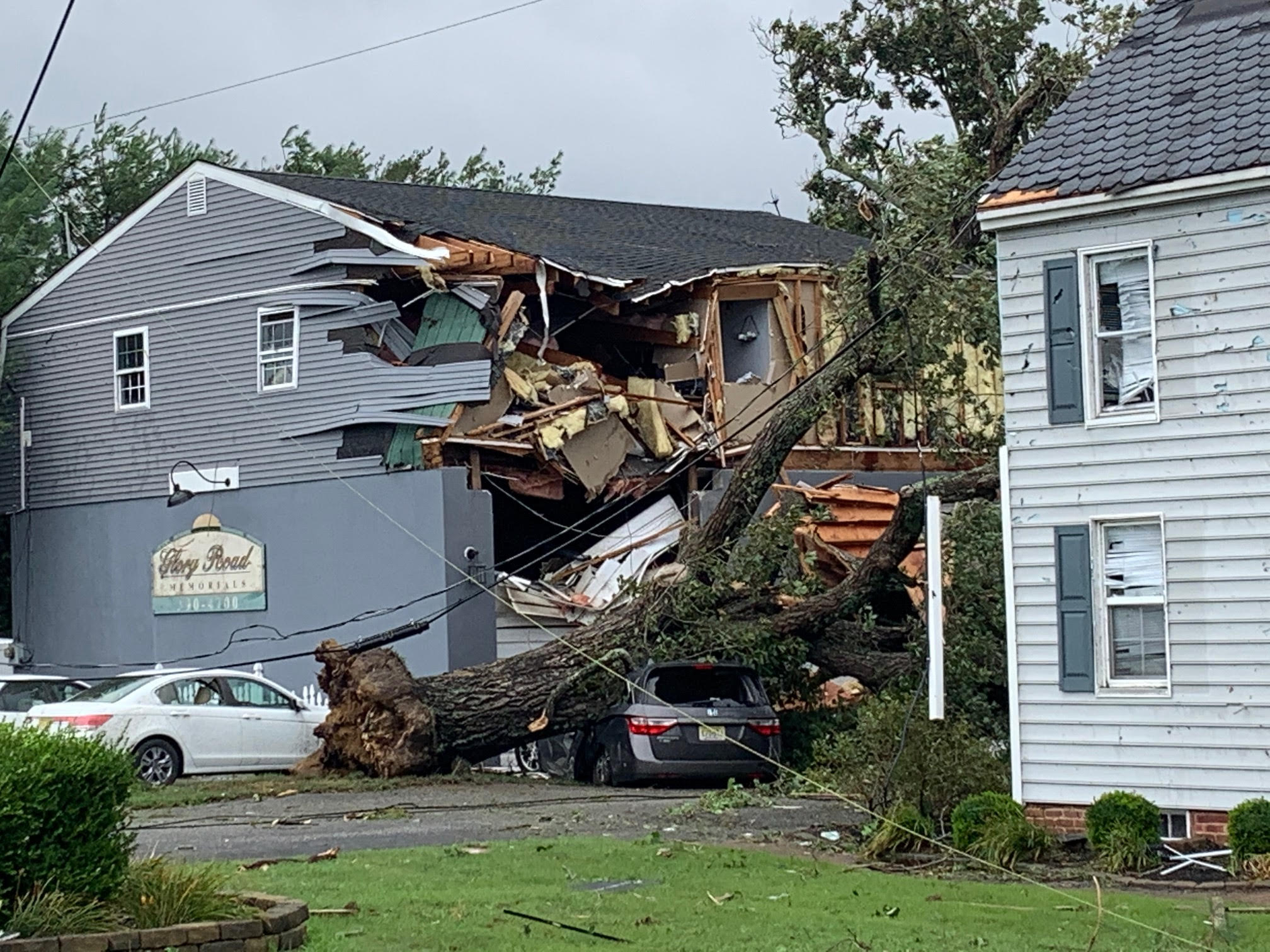
Besides the flooding, Isaias knocked out power to hundreds of thousands and spun up tornadoes and winds that damaged trees and homes as the storm screamed through the Philadelphia region Tuesday.
Here are the power outages in the region as of 2 p.m. Wednesday:
- More than 99,000 PECO customers in Bucks, Chester, Delaware, Montgomery and Philadelphia counties in Pennsylvania. The majority of outages are in Bucks and Chester counties.
- More than 61,000 Atlantic City Electric customers throughout South Jersey.
- Around 53,000 PSE&G customers spread out through Burlington, Camden, Gloucester and Mercer counties in New Jersey.
- More than 7,000 Delmarva Power customers in Delaware.
- About 4,000 PPL customers with most outages in Bucks, Lehigh and Northampton counties in Pennsylvania.
Isaias Causes Flooding and Damage Throughout Region
The wind picked up in Philadelphia midday as the rain started to taper off. Camden had a 60 mph wind gust with gusts of up to 75 mph along the Jersey Shore.
In Bucks County, the roof of a day care center at Doylestown Hospital was torn off, luckily no one was hurt. There were other reports of damage to structures throughout the Delaware Valley.
At least five tornadoes were confirmed, according to the National Weather Service. The twisters hit Bucks and Montgomery counties in Pennsylvania, Cape May and Ocean counties in New Jersey and along the Kent and New Castle county line in Delaware.
Among those were observed tornadoes in Sandtown, Kent County; Smyrna, Delaware, where 96 mph winds were reported; and near Strathmere, New Jersey; and another confirmed tornado was reported in neighboring Maryland Tuesday morning, the National Weather Service said.
The weather service has yet to determine the strength of the twisters.
Tornado warnings in the parts of Philadelphia, Bucks, Chester, Delaware, Montgomery and Northampton counties and the Poconos in Pennsylvania; Parts of South Jersey; and all three Delaware counties have expired.
See It, Share It: If you can safely take photos or videos of storm damage please send it to NBC10.
Inches of rain fell in many neighborhoods in a brief period of time as Isaias moved over the region. Some neighborhoods in Delaware, New Jersey and Pennsylvania were already reporting nearly 8 inches of rain by noon. That's a couple of months worth of rain in a matter of hours.
In addition to heavy rain and strong wind, the coast will also experience dangerous rip currents and coastal flooding. A coastal flood warning was in effect into early Wednesday.
Gov. Phil Murphy declared a State of Emergency for New Jersey Monday night ahead of Isaias. Motor Vehicle Commission offices were also closed Tuesday.
Isaias was downgraded to a tropical storm from a category 1 hurricane after it made landfall Monday night in the Carolinas, but it remained strong throughout the day before it moved out of our region.
Make sure you keep checking back with NBC10 News and download the NBC10 app for the latest on the storm's impacts.


