
What to Know
- Hurricane Milton is churning through the Gulf of Mexico toward Florida. The powerful storm was at a Category 4 status Wednesday afternoon.
- National Weather Service forecasters say it's expected to be a “dangerous major hurricane” when it reaches the Florida coast late Wednesday.
- Milton is threatening the Tampa Bay area, which is home to more than 3.3 million people and has managed to evade a direct hit from a major hurricane for more than 100 years.
One of the biggest storms the Gulf Coast of Florida has seen in years is nearing landfall.
Hurricane Milton dropped to a Category 4 early Wednesday as it churned toward Florida's west coast, but was still expected to deliver, "devastating to life-threatening impacts," the National Weather Service said.
The National Hurricane Center had predicted it would likely weaken, but remain a major hurricane when it makes landfall late Wednesday.
Get top local stories in Philly delivered to you every morning. Sign up for NBC Philadelphia's News Headlines newsletter.
Here are answers to some of the questions you may have about Hurricane Milton, which is being called
What's Hurricane Milton's track?
As of 1 p.m. on Oct. 9, 2024,, the storm was about 160 miles southwest of Tampa and moving northeast at 17 mph.
Weather Stories
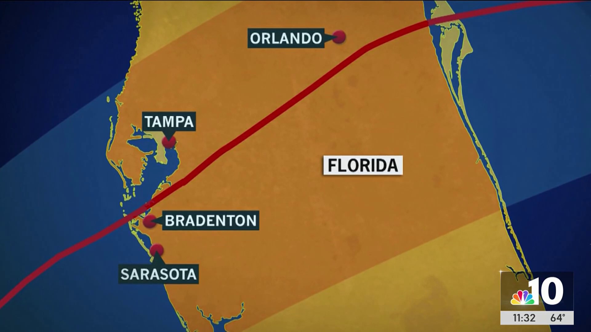

The current track has the storm striking somewhere near Bradenton and Sarasota, south of Tampa.
How powerful are Hurricane Milton's winds?
As of 1 p.m. Wednesday, the storm's maximum sustained winds were blowing at 145 mph. Winds of that strength fall under the Category 5 designation on the Saffir-Simpson Hurricane Wind Scale, meaning the storm was a powerful Category 4 storm as it moved closer to Florida.
When is Hurricane Milton expected to strike Florida?
"A northeastward motion with some decrease in forward speed is expected through this evening," the NHC said midday Wednesday. "A turn toward the east-northeast and east is expected on Thursday and Friday."
"On the forecast track, the center of Milton will move across the eastern Gulf of Mexico today, make landfall along the west-central coast of Florida tonight, and move off the east coast of Florida over the western Atlantic Ocean on Thursday."
Where is Hurricane Milton expected to strike?
“We must be prepared for a major, major impact to the west coast of Florida,” Republican Florida Gov. Ron DeSantis said Tuesday.
The exact spot where the storm strikes could still fluctuate, but forecasters expect it to be in the area south of Tampa Bay on the Gulf Coast of Florida.
Steady rain fell and winds began to gust in the Tampa Bay area Wednesday morning as a mighty Hurricane Milton churned toward a potentially catastrophic collision with the west coast of Florida. By midday rain was falling on much of central Florida.
Major bridges around Tampa Bay planned to close in the afternoon, said Cathie Perkins, emergency management director in Pinellas County, which sits on the peninsula that forms Tampa Bay, and public shelters were open for evacuees. Residents should not feel relief because of indications Milton's center might come ashore south of Tampa, she said.
“Everybody in Tampa Bay should assume we are going to be ground zero,” Perkins said.
How big is Hurricane Milton?
Rain bands from the storm spread most of the length of Florida as the eye of the storm neared land. That means the storms rain and winds could be felt over hundreds of miles.
Tropical storm warnings were issued as far north as Savannah, roughly 200 miles from the projected path of the hurricane’s center.
What are the expected impacts of Hurricane Milton?
Damaging winds and flooding are the biggest threats. Tornado threats also exist.
‘"Unfortunately there will be fatalities," DeSantis said. "I don’t think there’s any way around that," he said at a Wednesday morning briefing.
“Winds will begin to increase along the west coast of Florida by this afternoon,” the National Hurricane Center said in it’s 8 a.m. Wednesday update. "Preparations, including evacuation if told to do so, should be rushed to completion."
Tornado warnings continued to pop up during the day Wednesday. More than 12 million people in the state faced threat of tornadoes along with hail and wind, the weather service said.
Tornadoes had already spun off the storm ahead of its arrival.
The National Weather Service in Miami posted a photo on the social platform X of the funnel crossing the highway Wednesday morning with the words: “TORNADO crossing I-75 as we speak! Seek shelter NOW!”
TORNADO crossing I-75 as we speak! Seek shelter NOW! pic.twitter.com/VYhef71ulX
— NWS Miami (@NWSMiami) October 9, 2024
An apparent tornado touched down in a Fort Myers neighborhood near Page Field Airport Wednesday afternoon, well in advance of Hurricane Milton’s arrival.
Some residents along Florida's west coast insisted they would stay even after millions were ordered to evacuate. Stragglers face grim odds of surviving, officials said.
“This is it, folks,” Cathie Perkins said. “Those of you who were punched during Hurricane Helene, this is going to be a knockout. You need to get out, and you need to get out now.”
Flights to and from Florida were canceled Wednesday.
The foretasted tornadoes and up to 18 inches of rain — along with possible hurricane-force wind — prompted officials in the storm’s path in central Florida to urge people to reach their safe places immediately.
“Go now. Don’t wait. The time to be able to move around safely and make those last minute preparations is rapidly closing,” Polk County Emergency Management Director Paul Womble urged residents in a public briefing Wednesday morning.
Inland from the Tampa area and south of Orlando, Polk County is home to the Legoland Florida Resort theme park, which was closed ahead of the storm.
The weather will get bad after dark and flooding may even worsen over the next couple days as rainwater finds its way to the ocean, Womble warned.
“Once you’re hunkered down, just stay put. There’s no reason at that point to go out there. There will be trees down, there will be power lines down, it will be dangerous to move around,” Womble said.
Nearly 3,000 people already were in the county’s 19 shelters and there was still plenty of space for more, he said.
What is storm surge, how bad could it get?
"Storm surge is the abnormal rise in seawater level during a storm, measured as the height of the water above the normal predicted astronomical tide," the National Ocean Service says. "The surge is caused primarily by a storm’s winds pushing water onshore. The amplitude of the storm surge at any given location depends on the orientation of the coast line with the storm track; the intensity, size, and speed of the storm; and the local bathymetry."
The NHC issued a storm surge warning for Florida's Gulf Coast from Flamingo northward to Yankeetown -- including Charlotte Harbor and Tampa Bay, and, Sebastian Inlet, Florida, to Altamaha Sound, Georgia -- including the
St. Johns River.
"The combination of storm surge and tide will cause normally dry areas near the coast to be flooded by rising waters moving inland from the shoreline," the NHC said.
The biggest storm surge is expected from Anna Maria Island to Boca Grande where it could top out at 10 to 15 feet of water.

Gov. Ron DeSantis said to people choosing to remain home on barrier islands, “just know that if you get 10 feet of storm surge, you can’t just hunker down with that.”
“If you’re on the southern part of this storm, you are going to get storm surge,” DeSantis said.
“It’s churning massive amounts of water, and that water is going to come out,” he added. “Man, if you’re anywhere in the eye or south, you are going to get major storm surge.”
When was the last time a hurricane made a direct hit to Tampa, Florida?
The last time Tampa had a direct hit from a hurricane was on Oct. 25, 1921, according to the National Weather Service. "There were eight confirmed fatalities, nearly half due to drowning as the storm surge inundated near shore locations, and others from the hazards of the fallen debris like live wires."
The Tampa Bay area -- now home to more than 3.3 million people -- faced the possibility of widespread destruction after avoiding direct hits from major hurricanes for more than a century.
The normally busy interstate leading into downtown Tampa was mostly free of vehicles early Wednesday. Few cars moved on side streets. Drivers hoping to top off tanks were hard-pressed to find stations that weren't closed or boarded up. Many had plastic-wrapped their fuel pumps to keep nozzles from whipping around in hurricane-force winds.
In Hillsborough County, where Tampa is located, Sheriff Chad Chronister urged residents in a Facebook video to finalize their plans: “My message is simple. We’re approaching that 11th hour. If you need to get someplace safe for whatever reason, the time to do so is now."
Sign up for our Breaking newsletter to get the most urgent news stories in your inbox.