First Alert Weather
Live Blog EndedMar 5, 2025

Recap: Heavy rain, strong winds hit Philly region, NJ, Delaware

Get the latest updates on Wednesday's storm that brought heavy rain and strong winds to the Philadelphia region

Live

What to Know

  • A FIRST ALERT was in effect for the Philadelphia region from 2 p.m. through 9 p.m. on Wednesday, March 5, 2025, due to a storm that brought heavy rain and strong winds.
  • The worst weather hit during the mid to late afternoon hours, just in time for the afternoon and evening commute.
  • The biggest concern was damaging wind gusts. While the strongest winds at the Jersey Shore possibly exceeded 50 mph, gusts of 40 to 50 mph were expected inland, especially in Delaware and South Jersey, with a few locations possibly topping 50 mph.
  • The winds led to scattered tree damage, power outages, a temporary ground stop at Philadelphia International Airport and SEPTA delays Wednesday afternoon.
  • Along with the wind threat, the storms brought downpours leading to ponding on roads, isolated hail and even the possibility for an isolated tornado.
  • Get the latest updates on the storm by following the NBC10 First Alert Weather Team and downloading the NBC10 app.
MAR 55:12 PM EST

Power outages on March 5, 2025, as of 10:30 p.m.

PECO: 1396

Bucks County: 631

Chester County: 228

Delaware County: 227

Montgomery County: 88

MAR 511:23 PM EST

Rain moves out as winds stick around for Thursday

Rain moves out as winds stick around for Thursday
Thursday will stay dry as gusty winds make 50 degrees feel like 30. NBC10 First Alert Weather meteorologist Brittney Shipp has your forecast.
MAR 511:06 PM EST

Cleanup underway after strong winds, heavy rains

Cleanup underway after strong winds, heavy rains
Residents and crews are working to clean up their neighborhoods after strong storms moved through the Philadelphia region on Wednesday and left downed trees and flooded roads. NBC10's Brian Sheehan reports. 
MAR 58:35 PM EST

Storms wind down but some still see rain

According to the National Weather Service, the weather is winding down Wednesday night.

Some in our region may still be seeing showers and could even hear a rumble of thunder.

MAR 56:17 PM EST

Heavy downpours impacting evening commutes Wednesday

Heavy downpours impacting evening commutes Wednesday
NBC10's Brian Sheehan reports as he is on the road tracking Wednesday's storms. 
MAR 56:12 PM EST

Trees fall in Audubon, NJ, and Whitpain Township, PA

As thunderstorms move through our region, several towns are seeing fallen trees.

In Whitpain Township, Montgomery County, PECO is warning residents to avoid the area of Morris Road because of downed trees and power lines.

Morris Road is closed from Lewis Lane to Penllyn Blue Bell Pike.

And, in Audubon, Camden County, a tree fell onto the home of a NBC10 photographer.

He shared photos of the damage left behind.

MAR 55:45 PM EST

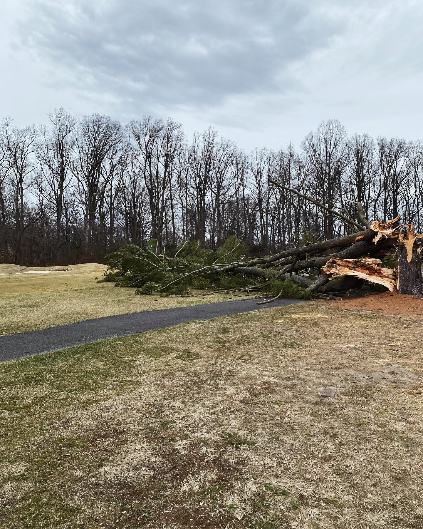
Massive tree falls on NJ golf course near holes 3 and 4

A golf course in New Jersey is dealing with cleaning up after Wednesday's storms brought down a tree.

The tree fell in between the hole three green and the hole four tee box at Pitman Golf Course on Wednesday, March 5, according to the course's Facebook.

Credit: Pitman Golf Course

No one was hurt when the tree fell, according to the course.

MAR 55:34 PM EST

Tree falls in Brooklawn, NJ, and takes down powerlines

It's a dramatic looking scene after a tree fell in southern New Jersey and brought down power lines near a major roadway on Wednesday afternoon.

The right lane of Route 130 in Brooklawn is closed as crews work to clean up the fallen tree and power lines.

MAR 55:27 PM EST

Driver's beware: Roads are starting to flood

PennDOT cameras are starting to show flooding on area roadways.

One spot in Philadelphia seeing a large flood is Interstate 76 on the westbound side near the City Avenue exit.

For more on the impacts to major roads in Pennsylvania, click here.

MAR 55:16 PM EST

Ground delay at PHL because of thunderstorms

Flights at Philadelphia International Airport are experiencing an average delay of 54 minutes because of Wednesday's thunderstorms.

MAR 54:40 PM EST

Strong line of storms move into our region

Strong line of storms move into our region
A First Alert is in effect for our region as strong wind gusts and heavy downpour rains move through. NBC10 First Alert Weather meteorologist Michelle Rotella has your forecast. 
MAR 53:39 PM EST

Ground stop at Philly International Airport

MAR 52:22 PM EST

Damaging winds, downpours, severe storms move through Philly region

Damaging winds, downpours, severe storms move through Philly region
Damaging winds, downpours and severe storms are moving through the Philadelphia region. NBC10 First Alert Weather meteorologist Michelle Rotella has the forecast. 
MAR 51:51 PM EST

PECO prepares for storm

MAR 512:33 PM EST

Timing and impact of Wednesday's storm

MAR 511:29 AM EST

Heavy rain, winds expected across Philadelphia region

Heavy rain, winds expected across Philadelphia region
NBC10 First Alert Weather meteorologist Bill Henley says a powerful stormfront is expected to move through the region on Wednesday afternoon. He expects wind that could be damaging and storms that could cause pooling to move along with this stormfront. 
MAR 510:47 AM EST

SEPTA expects delays due to inclement weather on Wednesday

SEPTA riders are being alerted that the inclement weather expected on Wednesday afternoon could impact their commutes.

On Wednesday morning, SEPTA officials, in a statement, encouraged riders to "allow extra time for safe travel and get the latest information before heading out."

SEPTA officials warned that heavy rain and strong winds could bring down overhead power lines and trees along Regional Rail and trolley lines and, crews were working on Wednesday morning to ensure they were ready to clear any tracks that might need it.

The mass transit provider reminded riders to check for real-time updates on septa.org/alerts, the SEPTA app, and by following @SEPTA on X.

Updates, officials said, will be provided throughout the day as new information becomes available.

MAR 510:15 AM EST

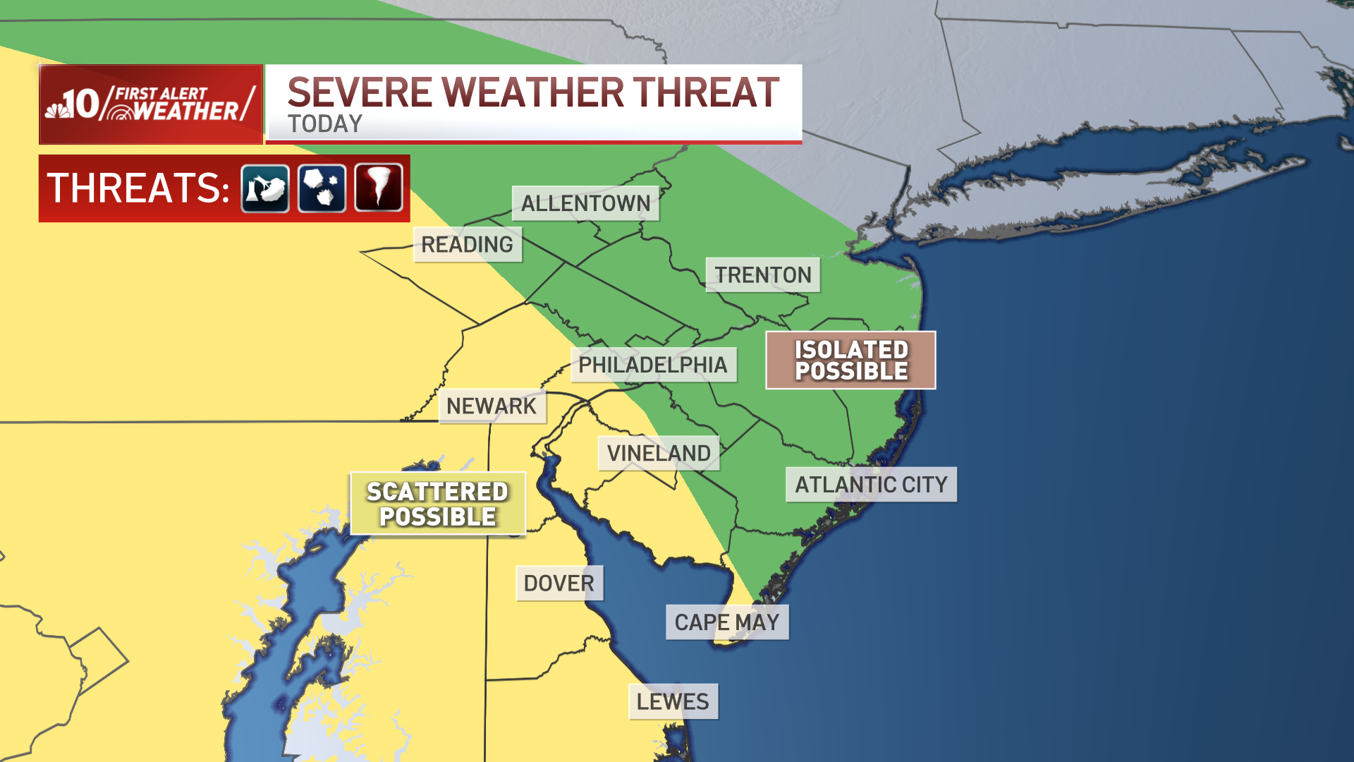
Photos: Timeline of Wednesday's severe weather threat

A FIRST ALERT is in effect for the Philadelphia region from 2 p.m. through 9 p.m. on Wednesday, March 5, 2025, due to a storm that will bring heavy rain and strong winds.
The biggest concern is damaging wind gusts. While the strongest winds will likely be at the Jersey Shore, possibly exceeding 50 mph, gusts of 40 to 50 mph are expected inland, especially in Delaware and South Jersey, with a few locations possibly topping 50 mph.
There is also the risk of an isolated tornado in parts of South Jersey and Delaware, though the risk is low.
The heavy rain is expected to move into the Philadelphia region around 3 p.m. and continue through the afternoon and early evening.
MAR 57:43 AM EST

Expect a cloudy, stormy Wednesday

Expect a cloudy, stormy Wednesday
NBC10 First Alert Weather meteorologist Bill Henley is calling for a cloudy Wednesday morning with storms expected to head into the region over the course of the afternoon. 
MAR 32:21 PM EST

Midweek storm to bring heavy rain, possible damaging winds to Philly region

Midweek storm to bring heavy rain, possible damaging winds to Philly region

NBC10 First Alert Weather meteorologist Bill Henley is calling for a cloudy Wednesday morning with storms expected to head into the region over the course of the afternoon. 

UPDATE: This article is no longer being updated. Get the latest updates on Wednesday's storm here

A powerful cold front is on the way and will bring a windy, rainy and possibly stormy Wednesday afternoon and evening in the Philadelphia region. 

The rain -- it's should be too warm for snow -- is expected to move in later on Wednesday, March 5, 2025.

Ahead of the front, gusty south winds will push temperatures into the low 60s in the Philadelphia area.

Read Full Article

Contact Us