Is it your imagination, or has it been one heck of a wet, windy spring?
Here's proof it's not all in your head:
- Severe thunderstorm and tornado warnings in 2019 have already surpassed all of 2018's total warnings for the Philadelphia region.
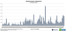
- Pennsylvania and New Jersey already have registered more tornadoes than the states' annual averages.
All the while, a rainy pattern sitting over Philadelphia since late May provides a near-daily reminder of the wetter-than-usual weather the region has been subjected to for nearly a year.
"Going back to mid-to-late July last year, all but two months have been above normal and those two below were pretty close," meteorologist Sarah Johnson of the National Weather Service in Mount Holly said.
Local
Breaking news and the stories that matter to your neighborhood.
The seemingly daily threat of thunderstorms this week also illustrates a bigger picture: Climate change melting ice in the Arctic has pushed the jet stream south — to us — and allowed for the kind of conditions that force safety officials to blow up your phone with "Emergency Alert" warnings.
Glenn "Hurricane" Schwartz, NBC10 First Alert Weather meteorologist, described the region's current weather as "an exceptional pattern" the last few weeks that could continue at least into next week.
The jet stream's southern course this year is due in large part to huge melt-off in the Arctic ice, Schwartz and other meteorological experts say.
The ice melt means warmer temperatures in the Arctic, which is pushing the jet stream south. It normally would be above Canada, meteorologists said.
Meanwhile, hotter weather in the southern United States has caused a wet pattern to stall over the mid-Atlantic.
All of it adds up to more rain and stronger storms.
"This recent outbreak of extreme weather is linked to a phenomenon (known as planetary wave resonance or quasi-resonant amplification) associated with a very wavy, stalled jet stream," Michael Mann, director of the Penn State Earth System Science Center, told NBC10 in an email. "This is when you get greatly amplified low pressure areas (which are associated with heavy rainfall), rotating winds with clashing warm/moist air masses that favor tornadic activity, that linger in the same locations for weeks at at time. Our work shows that this pattern is favored by human-caused climate change."
Pictures: Floods Force Residents From Homes in New Jersey
Get used to it, Schwartz said. What for decades may have been considered "extreme" weather patterns are becoming more commonplace, he said.
It's as if weather patterns are now "on steroids," Schwartz said: from thunderstorms in Pennsylvania to droughts in the west, to heat waves in the south.
"No one predicted this would occur now," Schwartz said of climate models from a generation ago. "Imagine what it’ll be like in 20 years, in 40 years."
There have been 134 severe thunderstorm warnings and 23 tornado warnings in 2019 in the region covered by the National Weather Service in Mount Holly, New Jersey. Those totals are more than the 110 warnings and 10 tornado warnings for all of 2018, according to data provided by meteorologist Sarah Johnson, who works at the Mount Holly station.
Still, despite what was a down year for severe storms and tornadoes, 2018's flash flood warnings — 113 — was a high for the last decade, Johnson found.
Actual tornadoes in Pennsylvania are trending higher.
Five of the 12 worst years for tornadoes dating back to 1950 have occurred since 2004.

Wetter weather and stronger winds are something residents of eastern Pennsylvania and New Jersey should get used to, according to David Robinson, New Jersey's state climatologist and a professor at Rutgers University.
"You can’t say day-to-day weather events are caused by climate change. However, you can say underlying our day-to-day weather is leading change in climate," Robinson said in an interview.
"This region is getting warmer, quite significantly, so we are in the midst of a climate change, a change that’s not stopping."


