Bitter cold and wind moved into the area after the snow moved out Saturday night. How long will the dangerous cold last? NBC10 First Alert Weather chief meteorologist Glenn Schwartz has the forecast.
LATEST ON THE SNOW
Snow has moved out of our area after falling in towns across the region, from central Montgomery County to the New Jersey coast, South Philadelphia to Burlington County.
The storm arrived before dawn at the Jersey and Delaware coasts, which put it on schedule with NBC10 First Alert meteorologists' forecast heading into the weekend.
HOW MUCH?
Delaware saw the highest snow totals in our area with 13.5 inches recorded in Ocean View, Sussex County. CLICK HERE for the latest snow totals from the National Weather Service.
The snowfall got progressively heavier through the day before moving out of the region around 9 p.m.
DON’T FORGET THE COLD
Arctic air continues to move in, and it’s just going to get colder and colder as we head toward the weekend. Here are predicted temperatures at 7 a.m. Sunday:

Remember, these are temperatures, not wind chills. I expect 15 to 30 mph winds Sunday, so wind chills should be down near ZERO in places.
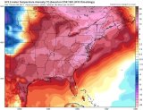
But, like other cold blasts this season, it’s not going to last for a long time. The warm up starts Tuesday, and look at the forecast maps for Wednesday compared to normal:
That’s the entire eastern half of the country with WAAAY above normal temperatures! We could even get back to 50-plus degrees that day.


